
Property information package
Flatwood 40 Tract
Flatwoods area, Marengo County, Alabama40± acres$140,000
01
Property overview
A manageable timber tract with an established hunting setup.
- Property typeRecreational / hunting / timber / potential rural homesite
- Acreage40± acres
- Listing price$140,000 · $3,500 per acre
- General useDeer and turkey hunting, recreation, timber investment, wildlife management and potential rural homesite use
- AccessApproximately 2,000-foot easement from Marengo County Road 14; no direct road frontage is represented
02
Property description
Mature timber, gentle terrain and a private Black Belt hunting getaway.
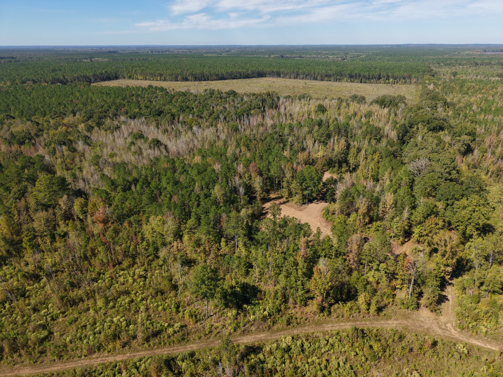
Located in the Flatwoods area of Marengo County, Alabama, this 40± acre tract offers hunting, recreation and timber investment potential. Nearly level terrain with a gentle natural roll supports mature mixed hardwoods and pine. Approximately two to three planted food plots, multiple stands and enclosed shooting houses provide an established hunting setup, with deer, turkey and wild hogs reported. Access is by an approximately 2,000-foot easement from County Road 14, with seller-reported documentation subject to verification and power available along the county road.
03
Location & directions
Access from County Road 14 in the Flatwoods area.
- State / countyAlabama / Marengo
- AreaFlatwood / Flatwoods area
- Address0 County Rd 14, Marengo County, AL
- Coordinates32.2063, -87.5394
- TRST14 R5E SEC 2
- Parcel ID22-01-02-0-000-003-0000
Reach the tract via an approximately 2,000-foot access easement from the county-maintained dirt road. Use the entrance location below and contact the team for directions and access arrangements before entering.
 Land ID map
04
Terrain, timber & wildlife
Predominantly level land, mature mixed timber and hunting habitat.
- TopographyPredominantly flat terrain with a very gentle natural roll; generally level and easily navigable
- TimberPrimarily mature mixed hardwoods and pine, providing wildlife cover and potential timber value
- DrainageSmall, shallow natural drainage feature; no significant creek or major drainage crossing reported
- WildlifeDeer, turkey and wild hogs reported throughout the tract
- Food plotsApproximately two to three established and planted plots; improvements summary reports approximately three
- Internal accessEstablished access to hunting locations and food plots
- HomesitesPotential cabin or rural homesite locations, subject to access rights, soil evaluations, utilities and permitting
05
Hunting improvements
The hunting setup is already established.
- Food plotsApproximately three established, planted food plots reported in the improvements summary
- Shooting standsMultiple established stands
- Shooting housesMultiple enclosed shooting houses
- Recreational improvementsExisting hunting setup and access to hunting locations
- Entrance accessApproximately 2,000-foot easement from County Road 14
06
Access, survey & legal
Verify the easement before purchase.
- Access easementSeller reportedly has recorded or deeded easement documentation for the approximately 2,000-foot access from County Road 14; documentation has not been independently verified
- Buyer verificationConfirm legal description, recorded status, maintenance obligations and permitted uses, including any utility rights
- SurveyNot supplied / N/A in the information packet
- Legal descriptionNot supplied / N/A in the information packet
- CovenantsThe packet identifies the access easement; other restrictions should be verified through title review
07
Utilities & local contractors
Power at the county road; onsite service remains to be confirmed.
- ElectricityAvailable along Marengo County Road 14; power on the tract itself has not been confirmed
- Public waterN/A in the supplied packet; availability not confirmed
- SepticA soil evaluation and applicable permits are required for a new installation
Septic & wastewater contractors
- Gaddy Electric & Plumbing — Demopolis · (334) 289-2822
- Twin River Contractors, LLC — Demopolis · (334) 216-2183Website not confirmed
Water & plumbing contractors
These local contractor contacts are provided for buyer convenience. Independently confirm licensing, services, availability and pricing. Septic installations require soil evaluations and applicable permits.
08
Zoning & land use
Agricultural classification reported; confirm jurisdiction and intended uses.
- MunicipalityUnincorporated Marengo County, Flatwoods area; municipal jurisdiction to be verified
- Current zoningAgricultural, as reported in the packet; confirm official classification
- Additional usesHunting, recreation, timber management and potential rural homesite development, subject to applicable requirements
09
Maps & due diligence
Aerial, topographic, wetlands, soils and septic suitability materials.
- Aerial mapIncluded
- Topographic mapIncluded
- FEMA floodplain mapN/A — no floodplain conclusion is represented
- Wetlands mapIncluded
- Soils mapIncluded
- Septic suitability mapIncluded; displayed ratings carry a scale-validity warning and are not a septic approval
- Survey / legal descriptionNot supplied / N/A
Maps are informational and do not replace a survey. Soil overlays do not replace site-specific evaluations or permits.
10
Pricing & closing costs
$140,000 · $3,500 per acre.
- Listing price$140,000
- Price per acre$3,500
- Total acreage40± acres
- ContractStandard REMAX Outdoor Group Land Purchase Agreement
- Earnest moneyTypically 1%–2% of purchase price
- Estimated buyer closing costs$800–$1,500, excluding lender fees
- Title companyLloyd & Dinning
Closing cost summary
| Item | Paid by |
|---|---|
| Brokerage commission | Seller |
| Deed preparation | Seller |
| Closing fees | Buyer / Seller (shared) |
| Title insurance | Buyer |
| Lender costs | Buyer |
Closing costs and payment responsibilities reflect standard practices and are negotiable. Final terms are determined by the executed purchase agreement.
11
Financing options
Local rural-land lenders in Demopolis.
Buyers may use the lender of their choice. Financing options and terms are subject to lender approval.
12
Viewing & next steps
By appointment only—contact the team before entering.
- 01Review the propertyReview the presentation, maps and available due diligence materials
- 02Verify accessConfirm the easement documentation, boundaries and permitted uses
- 03Schedule a viewingContact Team HaleSmith for entrance directions and access arrangements. Do not enter without an appointment
- 04Ask or submit an offerContact Team HaleSmith at 334-454-4571. The named listing agent and email are not yet confirmed
All property information is believed accurate but is not guaranteed. Independently verify acreage, boundaries, access easements, utilities, timber, wildlife, hunting improvements, drainage, zoning, soil suitability and intended uses. Maps do not replace a survey. Offered subject to errors, omissions, prior sale and changes without notice.
Ready to walk it?
Our team knows this ground. Ask a question or set up a showing.